Wednesday, October 31, 2007

Show Low, Arizona

Tomorrow morning we will leave our park here in Show Low and go East on the main street which is named Deuce of Clubs (also know as US Highway 60). But, I can’t leave without telling you the story of how Show Low got its name. You see, in 1876 two ranchers had laid claim to the same 100,000 acres. Their names were Corydon Cooley and Marion Clark. They agreed that the land would not support two families, but neither was willing to buy the other out. So………


……they decided to settle the matter by playing a game of Seven Up. They played at Cooley’s kitchen table. Clark was not faring well. He was holding a 3 (don’t ask, I have no idea how you play Seven Up, I only drink it with whiskey). So, seeing a way to win while he was down and almost out, he said “show low and you win the ranch”. Cooley drew the Deuce of Clubs. We’ve got a winner……..

He renamed the ranch Show Low and the road that went in front of his house to Deuce of Clubs. The town that later grew up along that road in front of his ranch also became known as Show Low.

Saturday, October 27, 2007

Fort Apache & the Kinishba Ruins

Located in the heart of Apache country, Fort Apache was established on May 16, 1870. The historic fort is near the present town of Whiteriver. It’s purpose was to assist the White Mountain Apache Tribe to peacefully protect their lands.

Fort Apache is perhaps most widely recognized for association with the famous renegade leaders from various Apache bands, such as Geronimo and Cochise. Geronimo was held in the stockade and local legend has it that he just disappeared right out of his cell. My local Apache source (cashier at the museum) tells me that what happened was that Geronimo buried himself in the dirt floor. When the guard came by with his meal, he found the cell empty and left the door open as he rushed off to sound the alarm. Geronimo them got up out of the dirt and snuck out.

This is the oldest structure remaining. It was built in 1871 as the commanding officer’s quarters. I think the picnic tables on the porch were probably added more recently…

Here we see the commanding officer’s quarters built in 1892. Pretty classy looking place. The army’s idea was that such structures would give the officers and their families some little bit of the back home trappings of civilization and take the edge off the desolation.
In 1923 the US government authorized converting the fort into a boarding school for the Indians. The school was named the Theodore Roosevelt School. Initially the children were housed in the old barracks, but in 1932 dorms were built. Here you see the girl’s dorm, still in use today. Although in earlier days there were hundreds of students at any one time, there are now less than 50.

Here we see some of the girl students circa 1975.


About 4 miles from the fort sits the Kinishba ruins, occupied between 800 and 1400 AD. There is no clear evidence that this was ever occupied by Apache. It was most likely built and occupied by ancestors of today’s Zuni and Hopi. The pueblo was restored between 1931 and 1939 by the Arizona State Museum, University of Arizona students, and Apache workers. Unfortunately the ruins were not maintained after that and have again fallen into disrepair.

By the way, both of these sites are designated National Historic Sites, but they are owned and operated by the White Mountain Apache Tribe, as is the school.

Monday, October 22, 2007

Petrified Forest National Park

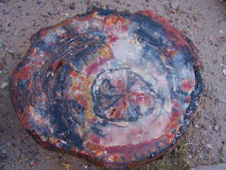
Easily accessible from exit 311 on I-40 in Northeast Arizona lies the Petrified Forest NP. Here I found fossils older than the oldest of my old fossil friends. The fossilized trees in the park started out in lush swampy lands more than 225 million years ago.

Petrified trees are not uncommon, they are found in all 50 states and in most countries around the world. The abundance here in the park, however, is greater than any other area in the world. The process that allowed the cells of the trees to be replaced by colorful crystal patterns is amazing, leaving behind beautiful “stone” trees.


The trees were immense, some over 200 feet tall. Although there are much larger and longer examples in the park, this picture gives you the idea.


PFNP isn’t restricted to fossilized trees. A portion of the park is in the famous Arizona Painted Desert. At sunrise and sunset the desert colors come out in full strength.


The land is rugged and was primarily formed by millions of years of sediment build up. It was sculpted into its current “badland” look by erosion from both wind and water. The colors come from the varied makeup of the layers of sediment. White layers are usually sandstone, reds are from iron stains, and layers of volcanic ash also contribute unique colors.


The land was also used by native tribes over the last 10,000 years. They were thoughtful enough to leave behind not only ruins of their dwellings, but their art work in the form of petroglyphs.


The park is also the site of many active research sites for paleontologists endlessly trying to sort out the animal and plant fossils in order to figure out what it was like 225 million years ago.

Monday, October 15, 2007

Going to Greer

As I mentioned in the last blog, we are in Show Low, Arizona. We came here to visit friends and because the park offers a special of $99 for the month of October. Not only is this a nice area, the price was right.

Okay, now about the area. Show Low is about 100 miles Northeast of Phoenix at the intersection of US 60 and Arizona highways 77 and 260.

This is NOT the Arizona that you think about when you day dream about fun in the sun. It is NOT creosote bushes, cactus, and blowing sand. This area is high, around 6,000 feet. The altitude keeps the temperature considerably cooler than the Phoenix area. When Phoenix is 115, Show Low is only in the 90’s. This area also gets quite a bit of snow in the winter, making for more moisture. The moisture makes for trees, real trees, like Ponderosa pine and Aspen. This part of Arizona is where the Arizonian desert dwellers escape for the summers.

We recently took a trip from Show Low to Greer, about 60 miles Easterly. The first two pictures are in Greer, a very popular, rustic, and small resort area. The other two are on Lake Hawley and along the road to the Lake.


I must make a small confession. I have touched up these pictures. I wasn’t satisfied with the color rendition my camera captured, so I puffed up the color a notch. For you purists, I apologize, for the rest of you, you are welcome. I am contemplating a new camera as this one seems to have suffered slightly from the fall we took off a skateboard ramp while in Canada. If I do buy a new one, it will be my third digital camera in the last four years. Hope the next one takes falls better the last two.

Tuesday, October 9, 2007

Leaving Montrose, Colorado

I had promised pictures of the fall colors around Montrose. Unfortunately, I had a family emergency (all okay now) and had to go to Indianapolis for about 10 days. This was right in the middle of the best color. Anyway, by the time I got back it was time to head out and look for warmer climes.

The need to head out should be obvious from this picture. The snows are in the higher altitudes right now, but heading down rapidly. Won't be long until there is snow on the passes. Leaving could get tough in a few more weeks.

I did find a few colorful spots on the way from Montrose to Cortez. There were more scenic views, but stopping along side the highway with a 34 foot trailer tagging along was too challenging for me. This is what I got you.......sorry.

Here's a shot of a small grove of Aspen, just so you can see they are really a goldy-yellow.


Sharon and I are headed for Showlow, Arizona where we'll spend three weeks visiting friends (and I'll play golf). We'll leave Showlow on November 1 and head for Las Cruces, New Mexico and then on to Big Bend National Park (in Texas). I am sure Big Bend will provide some great pictures.